Contents
Index
Import Shape File Parcels and Points
This will read in data for a cadastral network of Parcels and Points from and ESRI Shape file.
Two files are used.
The parcels (Polylines or Polygons) are in the shape file which has an extension of .shp.
Attributes for each parcel (name, date, plan, etc ) are stored in an associated .dbf file.
If there is any doubt as to the contents of the dbf file,
these tables can be viewed with a spreadsheet program such as Microsoft Excel.
Data in the .shp file has to be in Polygon or Polyline format.
If it is polyline format, the parcels that are generated will be flagged as being “Unclosed”.
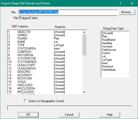
Enter/select the file containing the Shape Data to be imported in the top window.
Below that are two windows.
On the left is a list of the data tables held in the .dbf file
On the right is a table of the parcel data types.
To select data fields in the dbf file to be added tio the parcel
click on a DBF item, then cicl on the appropriate parcel field.
If there is no appropriate parcel data type to correspond with a dbf value, set it to be “unused”.
As a minimum, a column should be set for the Lot and another set for the Plan.
Shape data can be stored as geographic coordinates (longitude and latitude) or as
projected coordinates (east and north or X and Y).
If the data is in geographic coordinates tick the check box labelled “Data in Geographic Coordinates”
Note: First set the job Datum and Projection as Geocadastre will transform the geographic coordinates to that datum and projection.